

Pig Island: Geography primary resource
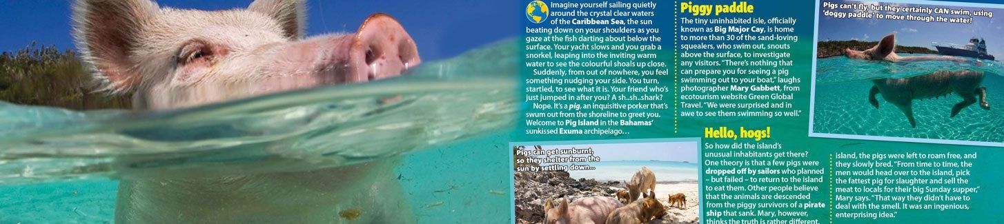
Discover Pig Island in Bahamas’ Exuma archipelago, which is home to more than 30 sea-swimming pigs!
This primary resource introduces children to a natural environment that is different from their own, located in a different part of the world. Discover Pig Island in Bahamas’ Exuma archipelago, which is home to more than 30 sea-swimming pigs! Where are The Bahamas situated? How many islands are in The Bahamas? How did the pigs get there?
Pupils will learn about the island in the Caribbean Sea and why is it a tourist destination in our National Geographic Kids’ Geography primary resource sheet.
The teaching resource can be used in study group tasks for learning more about the characteristics of Pig Island and its super swine inhabitants. It can be used as a printed handout for each pupil to review and annotate, or for display on the interactive whiteboard to share the information and photographs included in the resource and for class discussion.
Activity: Ask children to find The Bahamas on a world map. Do they know anything about the islands? Has anyone in the class ever visited? Pupils could design a poster or a leaflet advertising Pig Island as a tourist destination. Use this as a springboard for class discussion on what effect tourism may have on the island or on The Bahamas in general. Pupils could imagine they are visiting the island on holiday, and design and write a postcard home of their experiences.
N.B. The following information for mapping the resource documents to the school curriculum is specifically tailored to the English National Curriculum and Scottish Curriculum for Excellence. We are currently working to bring specifically tailored curriculum resource links for our other territories; including South Africa, Australia and New Zealand. If you have any queries about our upcoming curriculum resource links, please email: schools@ngkids.co.uk
This Geography primary resource assists with teaching the following Geography objectives from the National Curriculum:
- Pupils should extend their knowledge and understanding beyond the local area to include the United Kingdom and Europe, North and South America. This will include the location and characteristics of a range of the world’s most significant human and physical features.
National Curriculum Key Stage 1 Geography objective:
Pupils should be taught to:
- name and locate the world’s seven continents and five oceans
- identify seasonal and daily weather patterns in the United Kingdom and the location of hot and cold areas of the world in relation to the Equator and the North and South Poles
Pupils should be taught to: use basic geographical vocabulary to refer to:
- key physical features, including: beach, cliff, coast, forest, hill, mountain, sea, ocean, river, soil, valley, vegetation, season and weather
National Curriculum Key Stage 2 Geography objective:
Pupils should be taught to:
- locate the world’s countries, using maps to focus on Europe (including the location of Russia) and North and South America, concentrating on their environmental regions, key physical and human characteristics, countries, and major cities
- use maps, atlases, globes and digital/computer mapping to locate countries and describe features studied
This Geography primary resource assists with teaching the following Social Studies Second level objective from the Scottish Curriculum for Excellence:
- I can consider the advantages and disadvantages of a proposed land use development and discuss the impact this may have on the community.
Scottish Curriculum for Excellence Third level Social Studies objective:
- I can investigate the climate, physical features and living things of a natural environment different from my own and explain their interrelationship.
- I can identify the possible consequences of an environmental issue and make informed suggestions about ways to manage the impact.
- By comparing settlement and economic activity in two contrasting landscapes, I can reach conclusions about how landscapes influence human activity. I can explain my findings clearly to others.
- I can use a range of maps and geographical information systems to gather, interpret and present conclusions and can locate a range of features within Scotland, UK, Europe and the wider world.
Scottish Curriculum for Excellence Fourth level Social Studies objective:
- I can use specialised maps and geographical information systems to identify patterns of human activity and physical processes.
Download primary resource
More Like


LEAVE A COMMENT
THANK YOU
Your comment will be checked and approved shortly.
WELL DONE,
YOUR COMMENT
HAS BEEN ADDED!
COMMENTS
so this is the pigs secret?
CUSTOMIZE YOUR AVATAR